Kongsberg SIS (Seafloor Information System) is the industry-standard software for planning, acquiring, processing, and visualizing marine seabed survey data. It is a core product of Kongsberg Maritime, used primarily for offshore hydrographic survey, offshore construction support, and submarine pipeline and cable route surveys.
Core Concept of Kongsberg SIS
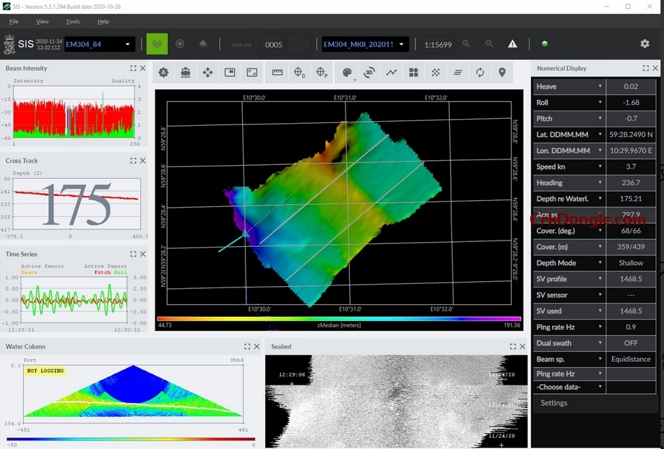
SIS is an integrated, real-time data acquisition and processing system. It takes in data from a vast array of sensors on a survey vessel (multibeam echosounder, side-scan sonar, sub-bottom profiler, GNSS, inertial navigation systems, etc.) and presents them in a unified, georeferenced view. This allows surveyors and hydrographers to ensure data quality in real-time and make critical decisions while on site.
Key Features and Capabilities in SIS 5.5
SIS 5.0 was a significant overhaul, focusing on modernizing the software for future development and expanding its capabilities.
1. Modernized User Interface & Architecture
-
New “Look and Feel”: SIS 5.0 introduced a more modern, intuitive, and customizable user interface compared to SIS 4.x. This includes re-sizable and dockable panels, making it easier for operators to tailor the workspace to their specific task.
-
64-bit Native Application: This was a critical upgrade. Being a 64-bit application allows SIS to access significantly more system memory (RAM), which is essential for handling the massive datasets generated by high-density multibeam systems.
2. Enhanced Data Acquisition & Visualization
-
Real-time Data Fusion: The core strength of SIS. It seamlessly integrates and displays data from all connected sensors in real time on a central 2D/3D map view.
-
Improved 3D Viewer: Enhanced capabilities for visualizing the seabed in 3D in real-time, including shading, texturing with backscatter data, and fly-through simulations.
-
Dynamic Vessel Model: Displays the survey vessel with all its attached sensors (like multibeam heads and sonar towfish) in their correct relative positions, updating dynamically as the vessel moves and pitches/rolls.
3. Advanced Planning and Execution
-
Line Planning: Create and manage complex survey lines (pre-lay, post-lay, corridor, etc.). SIS 5.0 offers improved tools for adjusting lines based on bathymetry or other data.
-
Autopilot Integration: Directly interfaces with the vessel’s dynamic positioning (DP) and autopilot systems to guide the vessel precisely along the planned survey lines.
-
Obstacle Avoidance: Integrates with obstacle avoidance sonars to ensure safe navigation and towfish operation.
4. Data Processing and Quality Control (QC)
-
Real-time QC Tools: Operators can immediately see data quality indicators like sound velocity profile effects, GPS quality, and noise levels.
-
Online Cleaning: Tools for manually or automatically filtering out water column noise and erroneous soundings (spikes) as the data comes in.
-
Backscatter Processing: Real-time processing and mosaicking of sidescan and multibeam backscatter data, which provides information about seabed composition.
5. Integration and Interoperability
-
Kongsberg Ecosystem: Designed to work seamlessly with Kongsberg’s own hardware, especially their EM Series multibeam echosounders (e.g., EM 2040, EM 712) and HISAS synthetic aperture sonars.
-
Open Standards: Supports standard data formats like S-57/S-63 for electronic navigational charts (ENCs) and can export to common formats (XYZ, GeoTIFF) for use in other software packages like CARIS HIPS and SIPS, QPS Fledermaus, or GIS applications (ArcGIS, QGIS).