HydroSurvey 7.0.3 is a point release in the HydroSurvey 7.0 series, a professional hydrographic survey software developed by CHC Navigation (CHCNAV) for marine and riverine data acquisition, processing, and mapping. a stability-focused update, it supports unmanned surface vehicles (USVs) like the CHCNAV Apache series, enabling precise bathymetric surveys, real-time positioning, and data visualization. This version emphasizes seamless integration with GNSS RTK systems and echo sounders, making it ideal for applications in dredging, port maintenance, riverbed mapping, and offshore construction. HydroSurvey facilitates end-to-end workflows from raw data logging to export-ready deliverables, reducing fieldwork time and improving accuracy in challenging aquatic environments.
The 7.0 series, launched in late 2024, introduced over 15 enhancements centered on multi-sensor fusion and automated quality checks. Version 7.0.3 specifically addresses minor GUI refinements and compatibility fixes for newer USV hardware, ensuring robust performance without disrupting existing workflows.
Key Features and Enhancements in HydroSurvey 7.0 Series (Including 7.0.3)
HydroSurvey 7.0.3 builds on the core 7.0 capabilities with targeted bug resolutions for smoother operation. Here’s a breakdown of the primary functionalities:
1. Data Acquisition and Real-Time Monitoring
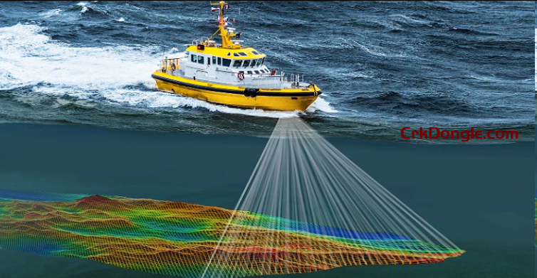
- Multi-Sensor Integration: Supports GNSS RTK receivers (e.g., CHC i83 series), single/multi-beam echo sounders, and side-scan sonars for synchronized data capture.
- Real-Time Display: Live visualization of depth soundings, track lines, and RTK positions on customizable 2D/3D maps, with self-diagnostic checks for signal quality.
- USV-Specific Controls: Intuitive setup for autonomous navigation via AutoPlanner integration, including beam angle adjustments and coverage planning for efficient survey paths.
2. Data Processing and Cleaning
- Filtering Tools: Advanced noise reduction algorithms for echo data cleaning, including tide corrections, refraction adjustments, and outlier removal based on user-defined thresholds.
- Matrix Generation: Automatic creation of color-coded depth matrices and contour maps, with support for variable resolutions (e.g., 0.5m x 0.5m grids).
- 3D Visualization: Generate interactive 3D surface models for volume calculations, cross-sections, and anomaly detection, exportable to formats like DXF or LandXML.
3. Mapping and Export Capabilities
- Georeferenced Outputs: Produce survey reports with depth contours, track plots, and statistical summaries (e.g., mean depth, coverage percentage).
- File Compatibility: Export processed data in standard formats such as ASCII, CSV, XYZ, or ESRI Shapefile for integration with GIS tools like ArcGIS or QGIS.
- Batch Processing: Handle large datasets from multi-day surveys with automated scripting for repetitive tasks.
4. Usability and Performance Improvements (7.0.3 Specific)
- GUI Enhancements: Fixed interface glitches for better object selection and property editing in high-resolution displays.
- Hardware Compatibility: Updated drivers for 2025 USV models, improving stability during long-duration missions (up to 8+ hours).
- Error Handling: Enhanced diagnostics for input validation, preventing crashes on malformed sensor files and providing clearer error logs.