AGS Res2DInv 5.0: Advanced Software for 2D Electrical Resistivity Tomography (ERT) and IP Inversion
AGS Res2DInv 5.0 is a professional-grade software package used for the processing and inversion of 2D electrical imaging data. It is designed for geophysicists, geologists, hydrologists, and environmental engineers to interpret data from Electrical Resistivity Tomography (ERT) and Induced Polarization (IP) surveys, creating detailed subsurface models.
Core Purpose of AGS Res2DInv 5.0
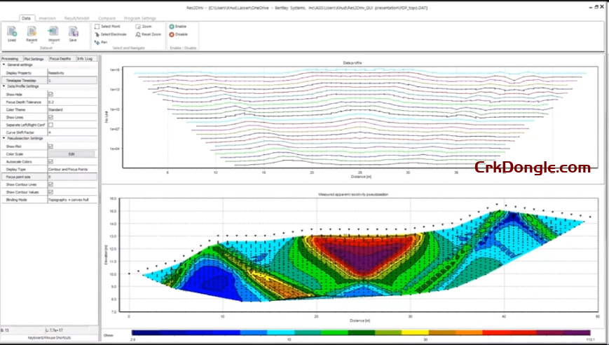
The software transforms raw field measurements of apparent resistivity and chargeability into a accurate 2D subsurface model that represents the true resistivity/IP distribution. This process, known as inversion, is crucial for moving beyond qualitative data to a quantitative geological model.
Key Features & Capabilities
1. Robust Data Inversion Engine
-
Smoothness-Constrained Inversion: Utilizes advanced least-squares inversion algorithms to create geologically plausible 2D models of subsurface resistivity.
-
Robust Inversion (L1-Norm): This feature reduces the smearing effect of sharp boundaries, making it better at delineating distinct geological layers or man-made objects.
-
Topography Incorporation: Accurately incorporates survey topography into the inversion model, which is critical for surveys on uneven ground to prevent misinterpretation.
2. Comprehensive Data Handling & Editing
-
Wide Format Support: Imports data from most major resistivity meters (e.g., ABEM Terrameter, Syscal, AGI SuperSting).
-
Data Filtering & Quality Control: Provides powerful tools to remove bad data points based on reciprocity checks, standard deviation, and misfit criteria before inversion.
-
Forward Modeling: Allows users to create synthetic models and calculate the apparent resistivity response. This is vital for survey design and testing interpretation hypotheses.
3. Advanced Modeling & Visualization
-
2D Inversion Sections: Generates high-resolution color-scaled sections of both resistivity and chargeability.
-
Depth of Investigation (DOI) Index: Calculates a DOI index to help users identify parts of the model that are well-constrained by the data versus parts that are more speculative.
-
Model Resolution Analysis: Provides tools to assess the resolution of the inverted model, indicating how reliable the features in the model are.
Primary Applications
AGS Res2DInv 5.0 is used across a wide range of fields:
-
Groundwater Exploration: Mapping aquifers, identifying fresh/saline water interfaces, and locating fracture zones.
-
Environmental Site Characterization: Delineating contaminant plumes, mapping landfill boundaries, and identifying leachate pathways.
-
Geotechnical Engineering: Locating cavities, sinkholes, and voids; mapping bedrock depth and rippability; assessing landslide structures.
-
Archaeological Prospecting: Detecting buried walls, foundations, and other anthropogenic features.
-
Mining & Mineral Exploration: Using IP data to map clay alterations, sulfide mineralization, and graphite deposits.
Typical Workflow in Res2DInv 5.0
-
Data Import: Load raw apparent resistivity/IP data from a field instrument.
-
Data Editing & Filtering: Remove erroneous data points and apply topographic data.
-
Inversion Setup: Select inversion parameters (e.g., smoothness vs. robust model).
-
Run Inversion: The software calculates the subsurface model that best fits the measured data.
-
Analysis & Interpretation: Analyze the inverted section using the DOI and resolution tools to interpret geological features.
-
Export & Reporting: Export the model section for use in reports, GIS, or integration with other geological models.